PS:
Before I'll tell you about my Monument Valley Trip I have to admit that (as some of you probably already noticed) I'm already about two weeks behind with my blog. That's mostly because of the desert- and mountain parts around the Sierra Nevada, I cycled through the last 14days, which have been most times really exhausting and after finding a place to sleep in the evening I fell to sleep immediately most of the time. But I try to write as most as I can and will definitely write about my whole trip till the very end! Although I also try to catch up to present time as fast as I can but I guess that I'll post the last entries after I got home from San Francisco then so I hope you'll enjoy reading although I'm a little bit behind. Let's get started:
When I woke up at my spot near Mexican Hat I realized what a beautiful place I chose for sleeping this night. Cause it was dark already when I arrived the evening before I couldn't see it but now just after sunrise I got an amazing view from my bed over a small canyon down to the valley:) Although it was such a nice spot I got up quickly cause temperatures have been rising already and I wanted to make it up to the Monument Valley Pass before it would get too hot.
 |
| Waking up like this... |
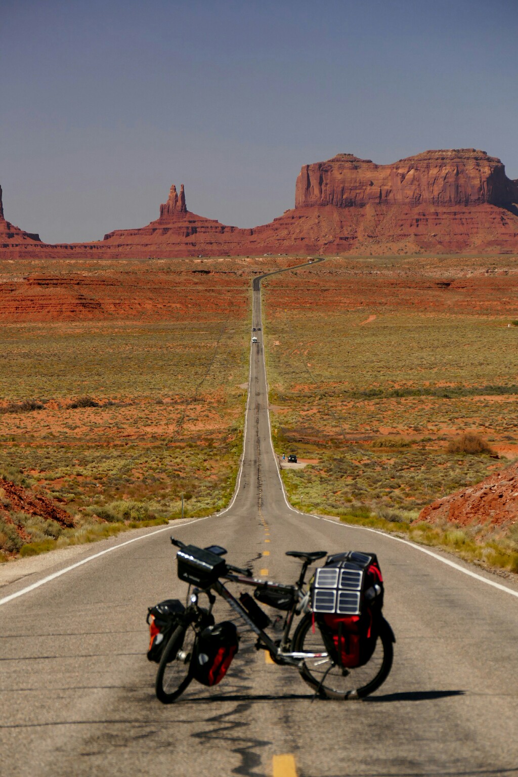
In the kinda "cool" morning-temperatures I got up the pass really fast and soon I had the first "monuments" in sight. Before you reach the very top of the plateau there's one amazing spot from where you can take amazing photos of the street going straight up towards the rock formations ahead. I've seen this spot already before on Google Earth and really wanted to take pictures with my bike here! Unfortunately many other people apparently have seen this spot on Google Earth as well so there have been at least 30 or more waiting for taking pictures!
 |
| Just an awesome view! |
Cause the best photo-spot was right in the middle of the street I had to wait even longer cause everybody had to let the cars pass by and it was a very busy street! But finally I spotted a gap in the traffic and got some cool shots with and without my bike:) As the only cyclist there I had to tell my story to lots of people there (an Asian tourist group and some German tourists I met there). The guide of the Asian group resisted on a selfie with me and gave me his email-address to get the picture afterwards:) From the German tourists I got two cold cans of coke, (actually I wanted to stay without drinking coke on this trip but considering the summer temperatures I simply couldn't say no as I probably wouldn't pass by a gas station during the next 4-5 hours!)
 |
| Same spot from closer |
 |
| And very close:) |
For those who haven't heard about Monument Valley yet: It is actually like a wide spread out plateau with lots of rocks who look like islands in the flat valley. They're probably deposits of a former higher plateau which eroded during the years and left these rocks consisting of a kind of more solid stone than the layer below (for further geological information use Google:)
Before I left the valley I wanted to see the probably most famous spot there: the three monuments or however they're called. Most people have seen these on photos before as I did but as I already have been so close I wanted to see them myself for sure. The best place to see them is from a small mountain ridge which was just a 6km detour and 100m uphill, so...why not? When I just got about 200m left to the edge of the hill then I had to stop at a gate. The woman there told me that it would be 6$ to get behind this point because there would be some special kind of park or something... 6$!!! just to get to this viewpoint and I was just a minute away! Usually I wouldn't support any kind of moneymaking like this but because I already rode 6km and uphill I didn't want that to be for nothing and payed. It was by far the highest amount I ever payed just to get a photo or probably the only amount I ever payed for something like this.
 |
| That's what I payed for! |
Well... at least the weather has been nice and the view was amazing! Considering the 6$, I really attempted to get the best photos possible. I even asked some people to help me lifting my bike up the stonewall to get a nicer picture with the Monuments behind. At the end I definitely got some really nice shots!:)
 |
| Lifted the bike up the wall:) |
But just because of the money I didn't want to spend too much time there and went on towards Kayenta, the next town on my way to Grand Canyon with hopefully lots of cold drinks! Just a few kilometers further then I reached the Utah border to Arizona. To be honest, it was a pathetic welcome-sign of Arizona compared to the one of Utah on the other side of the road. Utah has by far the biggest signs I've seen so far and I doubt that Nevada and California will top that. But anyway, a picture was a must-do and I went on into the state of the Grand Canyon (and the hot temperatures:/)
 |
| Arizona-welcome sign (from very close) |
 |
| Utah welcome-sign (from very far:) |
A few miles before Kayenta another cyclist passed me with lots of baggage on the back of his bike. He told me that he would be also cross-country cycling from coast to coast with two other guys but ending in LA then. When I asked him were the other two guys would be he said that they are behind cause they would be taking more stops than him but actually cycling faster. Wow! When he was already way faster than me, how fast would be the other two guys then??
Luckily I didn't met them so they didn't get the chance to let me look ridiculous with my 8mph in that moment:)
(actually I could have been faster but I would find out later why...again...).
 |
| Another few monuments |
 |
| Rumble-stripes blocking the whole shoulder, I know they're for safety reason but for cyclists they're just annoying! |
Once I passed Kayenta (got my cold drinks there:) I suddenly climbed up 500m on a pass I somehow missed on my map but at least it wasn't to steep and I could make it to the top before sunset - just one more climb to Grand Canyon from now on!
 |
| More rock formations |
The next day seemed to become a pretty casual one cause as my map told me it would be almost 90km slightly going downhill until I'll cross a valley from where the road to Grand Canyon would take off. Well... my map was half-right. Yes, it went slightly downhill but what I missed was that it went downhill to almost 1300m/4200ft what made the temperatures rise very fast!
 |
| Waking up with a cold can of coke!:D |
By the time I reached Cameron at the very bottom of the valley the temperatures have been risen to almost 41℃/106℉ and the sun burned like hell so I decided to move on quickly to get up the Colorado Plateau with hopefully cooler temperatures! (I hope the fire I saw the whole day from the distance up on the plateau would be on the north rim of the canyon, otherwise it'd get really hot up there:) But actually there wasn't any warning sign so I could hope the best)
 |
| :) |
 |
| It already looks super hot! |
 |
| Well... |
 |
| I do my very best:) |
Again I was half-right. Yes it got cooler, mostly because the sun was setting, but suddenly and out of nowhere a gusty wind was blowing down from the plateau directly into my face and slowed mw down sooo much! It didn't even stop after sunset so I just pulled over, totally exhausted when it got uphill steeper than before. It just wasn't possible to move on further on these steep grades with headwinds like that! At least for sleeping I found a nice place: one of these Jewellery-booths next to the street. For some reason there have been dozens of "self made jewellery"-booths on the past 100km/60mi, some of them abandoned and for sure nobody in there in all of them during the night. I even found a chair and a table where I could enjoy my meatball-sub (never carry a meatball-sub to long on a bicycle, it'll be soaked completely in the sauce afterwards and even doesn't taste really good anymore if it's cold!!) but the best thing was that it turned out to be a good shelter from the stormy winds during the night! Seriously, when I'll have time some day I will do some serious research about these desert winds here cause to me it doesn't make sense at all to get into some kind of storm during the best weather and not even close to the sea or some other flat areas!
 |
| Side canyon of the little Colorado River |
 |
| My sleeping-place for the night |
 |
| Pretty comfortable:) |
 |
| The big bush fire in the sunset |
The next morning the winds had stopped, finally! I was really afraid they would be still blowing cause I woke up from the noise the wind made, around 4am! But even without the winds I just climbed up the plateau kinda slowly, which made me really wonder why cause the tire pressure was alright and I couldn't find any other reason. I shot for latest 1pm at Grand Canyon Village to get to the Backcountry-Center in time to catch one of these last-minute permits for the Bride-Angel Campground down at the very bottom of the canyon, but with this speed it would have been a taff exercise!
 |
| Cycling in a shady forest again!:) |
Then I suddenly heard a noise and felt something definetly slowing me down now so I had to stop immediately!
When I turned my bike upside down then it turned out to be the axle of the back wheel beeing little bit out of place. For some reason you could move the wheel a little bit to the right and to the left now instead of being solidly attached to the axle. This made the wheel push hardly on the right brake-block what made it impossible to move on like this. My only chance was to adjust the left side of the axle a little bit higher than the right side to get the center of the wheel right in the middle between the two brake-blocks again, what I did. Definitely just a temporary solution but also the only one I got, and it worked! I guess this must have been like that for days and has been possibly what made me go slower and wondering why the other cyclists have been so fast! But it's never good to worry about the past so I was rather happy how easy it was now to cycle compared to before! I did at least 4-5km/h 2-3mph more than before and made it to the Grand Canyon Village on the south rim in no time. Although there have been some nice overlooks along the way I just stopped at the only one right next to the street (wow what a stunning view!) cause I rather focused on getting my permit in time and I would get a lot more stunning views later anyway.
 |
| Views from the canyon rim:) |
Around 1:30pm I got to the Backcountry Center which was closed for lunch between noon and 1pm. I wondered why it was still closed although it was already 1:30pm. So I first got myself something cold to drink and the woman at the counter told me that in most of Arizona they don't do daylight saving time which means that during summer time they are on the same time as the states in the Pacific Time Zone. Good to know! When I tried it then a second time on 1pm they where opened and I could ask for my permit:)
Surprisingly they had plenty of spaces available at the campground down at Grand Canyon for the next day although there's actually a lottery for the permits for which you have to apply at the beginning of the year. Probably many people cancelled because of the heat or something else. Whatever it was - good for me:) The guy in the office asked me several times if I really wanna do this because of the temperatures (it can get 120℃ down there) but I assured him to start early so he finally issued me the permit. They probably tell everybody that you gonna die down there and exaggerate a lot l but it's probably better like that so they avoid people going down less prepared, unequipped or overestimating themselves.
But they've been actually really nice people and even before I got the chance to ask they offered me to store my bike in the office until I would be back. So basically everything was managed before 2pm and I could spent the rest of the day with preparing, eating and hanging around in the village. They even got a nice littlel bus-network system which is for free and the bus drivers tell you about what you can see outside and some background information while you're riding.
Around 8pm I wanted to go to Matha Point on the canyon rim to watch the sunset there. Unfortunately at least 200 other people got the same idea so the spot was actually pretty packed and it was nearly impossible to get close to the fence! I still got some nice shots and looked for a place to sleep after that soon as I wanted to catch the 4am Hiker Express to the South Kaibab Trailhead the next morning. Unfortunately I left my sleeping bag in the Backcountry Center with my bike cause I would not use it during a 90℉/32℃-night down in the canyon. What I didn't think about was that I had to stay the night before up at the rim on 2000m/6500ft where the temperatures dropped down to almost 12℃/54℉ and it was simply impossible to sleep under the sky without any kind of cover. But because I had to get at least a tiny little bit of sleep I decided to stay in one of the bathrooms of the National Park Center. That actually sounds worse than it is cause the bathroom has been really clean and I could lock it from inside so I could have a nice sleep without anyone bothering me. Even if someone (and I didn't expected that at all at this time) would see me walking out there before 4am I could have just pretended to having used the toilet there. But no one came and I could sleep at least for 3 hours until I got up again around 3:45am.
 |
| Matah-Point at sunset |
 |
| The big bush fire on the other side |
 |
| The same as a long exposure shot later in the night |
 |
| The bush fire from closer |
 |
| And finally my route:) |


Did you know you can create short links with AdFly and earn money for every click on your short links.
AntwortenLöschen