Places I'll probably go are: Salt Lake, Arches National Park, Canyonlands, Monument Valley, Grand Canyon, Las Vegas (just for taking a picture and it's on my way:D), Los Angeles, Mount Whitney, Yosemite Valley and finally a short section up the Westcoast to San Francisco:) When you draw a route along these places you'll see that it's at least the distance I already did so far, if not even more.
 |
| Estimated route do San Fran (not 100% correct but almost) |
But let's face the following week. The next day off, I planned to take in Grand Junction (western Colorado). Friends of the Halens I visited in Ohio live there and already texted me that I could stay a night or two at their home.
On the day off in Denver Brian told me that Colorado is the only state in the US where it is legal to smoke weed. Like in the Netherlands you can find shops apparently everywhere but I haven't seen one yet. Maybe I should take the chance before I'll cross the border to Utah but I'll see:)
The shortest route to Grand Junction which doesn't follow I70 the whole way is about 550km and goes over four passes, two of them more than 3600m (11800ft) high. That would be higher than the highest mountain I ever climbed on!
On the first day I tried to get up early cause I had to buy a new pair of shoes and a bear-spray (it's like a giant pepper-spray, cause a few people told me that's a nice thing to have if one of the many bears in the Rockys would try to get some of my precious food:) Well, that I failed getting up early was for sure anyway, but what slowed me down more was to find this bear spray. Walmart, where I got a really good new pair of shoes for just 19$ by the way:), hasn't got bear spray at all so I had to find a shop for outdoor equipment to finally get a spray for 40$! (If it's worth it?) I don't know if that's the usual price but it seems quite expensive for a simple spray to me.
 |
| New Shoes:) look at the holes in the old ones! |
 |
| Bye bye old shoes:/ did a great job around the world:D |
In the end it got 2pm when I finally was out of town and ready to face the first pass on my trip. The route to Loveland Pass follows highway 40 and later highway 6 next to I70 all the way till it spreads off before the Eisenhower tunnel.
 |
| Leaving the flat parts :) put a flag on my bike now as an indication for cross-country cycling, I hope I'll find a German flag as well! |
The beginning was quite steep (up to 12%) but I could make good altitude and soon hit the 2300m-mark, almost my record which is 2330m on the Bernina Pass in the Alps what I did with a friend during our bike trip to Venice 2012. But first it went down again to the Clear-Creek Valley where highway 40 joins highway 6. On this downhill part you can't avoid going on I70 for about 3km, what I'm not sure about if it's allowed but there is simply no other road on this short part. I had no choice anyway and in the end it wasn't a problem at all cause you could cycle on this huge side-lane which a few other cyclists did as well so it seemed to be a common thing anyway.
 |
| Going on I 70 |
 |
| Entering Clear Creek Valley |
In the Clear Creek Valley you either cycle on a small side road or sometimes even on an well maintained asphalt-bike path, what a luxury! The valley doesn't go uphill to steep but steadily so according to my map you do most of the difference in altitude during the 50km in the vally and the actual pass-road at the end just goes up 400 more meters. Of course I shouldn't forget to mention that the views of the snow-covered peaks ahead are stunning all along the way! I totally enjoyed to finally be in the mountains, it's just so much more exciting to ride here then the few weeks before. Not even the fact that I have to share the valley with the traffic on I70 can lower my excitement:)
 |
| I 70 always close, but still really nice to ride:) |
 |
| Idaho Springs |
Half of the way to the pass I got it then:) After being on my longest bike trip ever (Indianapolis - 1600km), doing the longest stage ever (June 20th - 263km) and cycling the fastest average speed (June 18th - 21,1km/h) I set my fourth record now, cycling on an altitude of 2331m, higher than ever before and I haven't been even close to the summit:) By the end of the day, when I found a place to sleep next to the road I had already reached an altitude of 2850m (9350ft) - my highest sleep ever (if I can count that as a record).
 |
| Higher than ever before! |
 |
| Now higher than the highest mountain in Germany:) |
 |
| And higher than 3000m:D |
The next morning I tried to get up early (still my favorite joke:) But it actually hasn't been to late (9:30am). It was just so comfortable and warm in my sleeping-bag cause due to the hight the temperature dropped below 10℃/50℉ in the night.
 |
| Spot for the night:) |
The following few kilometers to the start of the pass-road are on a bike trail again which had some steep parts in it but you can't complain really considering that it's going 400m uphill.
 |
| Nice bike trail, even divided! |
 |
| Raft, passing by:) |
On an altitude of 3200m (10500ft) I70 goes into Eisenhower-tunnel and highway 6 goes the last couple of miles up to Loveland Pass. Only annoying thing on this final part are the fuel-trucks which are not allowed to drive through the tunnel and need to take the pass-route instead. But I think that the tunnel still keeps most of the traffic away from the pass and more than 4 trucks haven't passed me anyway. For these last 400m of altitude I needed almost an hour, what could be because of less oxygen in this hight or just because it was so steep!
 |
| View down from the pass road to Eisenhower tunnel |
But finally after 3hours from the start I reached the highest point I've ever been on in my life!: Loveland Pass: 3645m (11990ft)!:D The final climb to this pass and especially the arrival has been the absolute favourite part of my trip so far! It's not just because I set a new personal record reaching the summit, it has been mostly because of the support you get from people passing you going uphill. I think the thing is that cycling in the US (although more people are doing it here in the Rockys) is still a pretty uncommon thing, most people not even get the idea of using a bicycle and most times there are simply no bike trails which makes it really hard to get around with a bicycle. But anyway I guess because of so less people doing it you're becoming kind of the main attraction especially on pass-roads like this when you're the only heavy-loaded bicycle between dozens of cars. The cool thing about that is that so many people are cheering at you, shouting: "Go go go" or usually blowing their horns and waving out of the window:) That gives you pretty much the double amount of motivation during climbing up the road but it hasn't been the best part yet! When I reached the pass-summit their was a group of about 20 hikers who have been standing next to the pass-sign. The moment they saw me, they started cheering and applauding like when there would be a competition going on and you would reach the finish-line first:D It was just incredible getting such a nice and surprising welcome after climbing up the mountain for hours, definitely my favourite moment so far!:D But still not enough with that: When a sudden thunderstorm was approaching a couple, stopping at the pass for a short look, asked me to sit in their car for a bit. Although the thunder went away very quickly it became a little longer stay as I was telling them my story and they asking me more and more about my trip:) They offered me some snacks they brought with them but with all the extras (fruits, crackers etc.) it ended up being quiet a good lunch:) They've been really surprised that I've met just nice people along the way so far, maybe it was because he has to deal with many bad people as a police officer, but they have been the best example to proof the fact with just meeting nice people:)
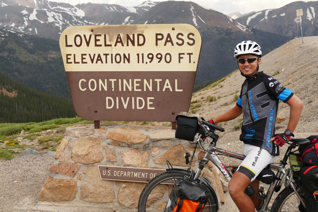 |
| Highest point ever so far:) |
Before I started the downhill-ride I thought being on such a high point would probably be the best moment to put new brake blocks on as the current ones have been pretty much worn out already. It took me almost an hour to change them cause these hydraulic brakes are not as easily removable as other ones so the only options are to disassemble the whole brakes and adjusting them again afterwards or letting all the air out of the tire and removing the wheel (way faster). Cause unfortunately I've just got a small pump I wouldn't have been able to put in the same pressure again so I had to choose plan B, I hope they'll last for a long time!
But then I was ready to start my well-deserved descent down the valley on the other side.
One thing what makes the Rockys so different from the Alps in Europe you notice immediately when you're riding down Loveland pass. It's the treeline. Once you hit the 3400m-mark you're already deeply into the forests, totally different than back home where you just have to climb up to 1800-2000m to get out of the woods. Because of that the mountains around here reminded me more of the black forest in Southwest Germany (max. 1400m high) than of the Alps which are pretty much same high as the Rockys. So if I wouldn't have known it from the map I would have never guessed to be that high.
The only thing that reminds you of being that high are just the night temperatures and a few snow fields left from the winter. But during the day temperatures even rise considerable on the pass summit so it would be easily possible to walk around in a T-shirt on 3600m!
On my downride I got quite strong headwinds blowing up the valley but it didn't bother me at all this time cause it kept me at a speed of about 40km/h (25mph) almost without using my brakes so I could rest them. Down the Valley (the Valley was still 2800m/9500ft!) in Silverthorne I had to stop at a bike shop getting my quickstand fixed (one screw was missing) and inked to repair one of the poles of my tent which I broke the night before:/ Before I left I couldn't resist to buy a deck of cards with Colorado's 14000ers:) After this second longer stop that day I already lost too much time to do the following pass (Fremont Pass) the same day so I tried at least to get as close as possible to have an easier climb the next morning.
 |
| Fixed the pole with Gorilla-Tape, feels even more stable than before now!:) |
 |
| Cycling down Loveland Pass |
During another short stop at a supermarket (I guess I wanted to buy cereal or something) I saw an offer for 8 really big chicken wings for just 6$! I know it is a big mistake to go hungry to a supermarket, cause somehow I found a big potato salad (5$) on my bill as well. Way to much for dinner but at least it was in a plastic box so I could carry it with me as a breakfast for next morning:) After this third long break it already was 7pm and I didn't even cycle 60km!! so I tried to make it at least past that point where I70 takes off into another valley so I would have a quiet place to sleep somewhere next to the street.
 |
| Chipmunk along the way:) |
 |
| Way to much, even for me:D |
 |
| Up the valley towards Fremont Pass |
As I finally made it to this point, sun was already about to set and as I looked for a place to pitch my tent I suddenly spotted a free campsite on the left side of the road! No kidding! Many people camped there just pitching their tents or sleeping in a campervan. It has been the first free campsite I saw in the US far from any major bike-trail and it was just the perfect timing! Without any cooking I could just pitch my tent and fall asleep.
 |
| My place for the night |
The next morning - I was still in my tent - the guy camping next to me, Daniel, left me some of his breakfast on a plate including coffee! It was scrumbled eggs with fried potatoes and ham, what a nice morning surprise! I put some of my 30 cookies I bought the day before (like I said, never go hungry to a supermarket!) on a plate as a thank you for this delicious meal:)
By the way, new high-sleeping-record: 3015m ;)
 |
| King breakfast:D |
The remaining 400m uphill to Fremont Pass (3450m/11200ft) went pretty fast and also because the views haven't been that spectacular than on Loveland Pass, I just took the obligatory photo and continued downhill.
 |
| Fremont pass summit:) |
 |
| Valley past the pass |
This time the headwinds have been that strong that I sometimes even had to move my pedals, downhill!! Even the cyclists coming uphill seemed to be faster than me. But eventually I made it down and ended up in a small town called Leadville. They had a big street-party going on so the main street wss blocked my hundreds of people and I had to walk my bike through town. Cause I found a WiFi in a cafe my lunch-break extended to two and a half hours so again in the evening I didn't even made 50km!
 |
| After Leadville |
 |
| " |
Again my plan was then to reach the foot of the next pass (Independence Pass) to have an easier climb the next morning. But the wide valley I rode through after Leadville with its wide spread out dry grass lands and the stunning panorama of Colorado's 14000ers (4300ers in meters) including the highest mountain of the Rockys, Mt. Elbert (4397m/14426ft), made it hard not to stop every minute for a photo:) cause the landscape around here is just incredible! Although there're always some houses anywhere everything seems still so untouched. To convince yourself, just watch the photographs:)
 |
| Mount Elbert |
 |
| Road next to Twin Lakes |
Before I entered the woods in the Valley up to the pass I quickly had the rest of the chicken wings and the potatoe salad and washed everything clean in a nearby river cause as people told me you should never leave food around you when camping in the Rockys and as I'm camping just anywhere usually there's probably a pretty good chance to meet one. Just after entering the valley there was a campsite right next to the river but it was still an hour to sunset so I decided to take the risk and hope for one of these unmarked campsites along the road. But unfortunately in the next hour I passed none of them so I was almost about to camp just at one of these turn-outs when I suddenly saw a car and a tent standing like a hundred meters away between the trees. When I entered a small gravel road to the left I saw then a couple tents more:)
I did it again! Just in time I found another of these unmarked sites and it was a pretty nice one as well right next to the river.
And another time I was glad that I had a proper sleeping bag with me cause it was fu**ing cold during the night! Due to this hight (3200m/10500ft - another high-sleeping record by the way:) temperatures went down to almost 5℃/40℉ during the night, what a difference compared to the 28℃/82℉ during the nights in Kansas last week.
 |
| Stunning views:) |
Getting up was really hard the next morning cause the difference in temperature between my sleeping bag and outside was huuge:) But I still got on the road quit early cause I wanted to make it to Carbondale, a village 80km/50mi from where I was, by 4pm, cause SWR3 - the radio channel wanted to call me another time and I definitely didn't want to miss that. (Hoped for reception in Carbondale of course:)
But first I had to climb up Independence Pass. The final ascent was a 6km/3,7mi steep road climbing up another 450m/1480ft to the summit. But because it was the start of the day I was in perfect shape and after almost an hour I reached the summit of my whole trip!!
 |
| On the way up |
Independence Pass with its 3688m/12095ft is for sure the highest point on my tour and even the highest elevation I've ever been on!! Let's see how long this record lasts. Maybe longer than last time but probably not forever:) A summit-photo was a must-do so I looked for someone with a big camera, a sign for photography-skills:) The two girls I asked first, have been a bad choice:/ I mean I'm usually not that picky with photos but this was an important one for me and seriously people!, don't buy big cameras if you you don't know how to use them! The second person I asked did it way better! Finally got a perfect shot:)
 |
| Did it!:D |
 |
| Lake on Independence Pass:) |
The following downhill ride was just em... awesome and stressful same time. The awesome part was that the bottom of the valley I rode into was 1000m/3280ft lower than the one I came from (meant a 1800m downhill ride) and even after Aspen (30km/18,5km after the summit) it went slightly downhill, the whole remaining 50km/30mi till Carbondale!
The less awesome part was that till Aspen it was apparently a very old road with lots of bumps abd potholes so I couldn't go faster than 30km/h / 18,5mph if I wouldn't risk another wheel.
 |
| Bottle under pressure after a 1200m downhill ride! |
Once I passed Aspen the scenery around suddenly changed a lot! From green mountain forests with lots of fir- and pine trees to just bushes with a couple of cottonwood trees along the river. It reminded me a lot of the maquis in Greece where usually just bushes grow like here.
Although it has been already three weeks now since I passed the ripe cottonwood-trees in Ohio, apparently due to the higher elevation these trees just became ripe around here and it was bad...! Way more cottonwood-flakes in the air than I've ever seen before! At some places even that much that whole streets have been completely white, covered with a 5cm layer of cottonwood!! I didn't take a photo cause I wanted to get out of that as quickly as I could:D
The following 50km to Carbondale I could ride on a bike trail. It was paved the whole way and, slowly going downhill, allowed me riding 25km/h / 16mph or more! In no time I made it to Carbondale, found myself a nice cafe with WiFi and texted the radio channel. Not even half an hour later I got the call and we talked like last time for a couple of minutes about my trip. The host of the show was very interested in my bear-defending spary and how to fight bears with it but we also talked about cycling in the rockys and over the passes for sure:) At the end of the called he asked me to talk another time the next day or the day after. He seems definitely very interested in what I'm doing and apparently it seems to become a weekly-thing from now on, thats so funny!:) I just wonder if I could make it every time to a place with good reception but as many times as he calls me it probably wouldn't matter if I would miss one or two calls.
After the talk I did some of the ascent of the last pass on my route to Grand Junction and cause this time there was just an 28$-campsite, I just pulled over anywhere.
 |
| Place I pulled over |
During this night I had some very frightening moments. I woke up because of some noice and heard that some kind of animal was walking around my tent. That happened a couple of times that night but it never came really close to my tent so I expected it not to be a bear, maybe rather a weasel or or a big rat. But cause there're many bears in this part of the Rockys I was very afraid that one of these noises could be one of them, but luckily it wasn't. Not a good sleep that night:/
When I wanted to have breakfast the other day I found out that I apparently filled some kind of soap-water in my water bag back in Carbondale, so the whole water I had was undrinkable!! Cause it was still more than 60km/37mi to the next town I had to get some water in between! Cause there was no place to refill my bag really, I used water from the river, which was very clear here in the mountains, but just to be sure I cooked it before. A few kilometers further I found then a very clear creek coming down the mountain and I decided to use this water for drinking until I would get to the next village! Next time I'll check the water definitely before so something like that can't happen again! Sure, here in the mountains with all the clear creeks it's not a problem but if you're in drier areas it could become an issue for sure!
But anyway, the water from the creek was very good and with its help I climbed up the rest of McClure Pass the last one in the Rockys and the lowest one as well (just 2669m/8755ft).
 |
| On the top of the last pass! |
 |
| View from the road:) |
From there it goes down to almost 1400m/4600ft till the city of Delta so it's quite a nice downhill ride. The road follows a nice little valley till that one opens to a wide spread out area at the village of Paonia. I found a subway there were I had lunch and could refill my water bag with treated water so I was definitely save from any bacteria now.
 |
| Sign along the way, if I should be afraid?o.O |
Actually I didn't expect to be so fast and cause it has been just 2pm (still 7 hours to sunset) and it was "just" 110km/68mi more to go I decided to make it to Grand Junction this day and take a day off the day after.
Shortly before I reached Delta the scenery changed again and as I left the big mountain forests just two hours ago I was now out of a sudden... In a desert! I knew that this would be coming as soon as I would get out of the Rockys but this came way faster than I expected! Nothing but foot-high dry bushes and no sign of water (except of the nearby Colorado River). Cause there was obviously not much to see except of dry grass and bushes, rocks and dirt I could continue quickly on my way to Grand Junction.
 |
| Riding on highway 50, the only way to GJ! |
 |
| Nothing but a bike:) |
 |
| So different and close together: Desert below and d forest on the top! |
But there was one funny thing about this part all along the way: Meerkats everywhere! I first thought there would be birds around me cause the noise they make pretty much sounds like some kind of birdsong but there were no birds around so I wondered a couple of minuted where this noise comes from until I spotted them on the ground. Never saw them before anywhere but they really act like in all the animal-documentaries I've seen, standing in front of their holes in this funny position:) Got I few nice shots of them what turned out to be very difficult due to the meerkats being very shy!
 |
| Meerkat, looking suspicious:) |
Finally just right around sunset I arrived at Werner & Carol Dueckers home in GJ. I had a very nice arrival, had a refreshing shower and a nice dinner until I went to bed very quickly, having done more than 180km/112mi that day:)
 |
| Almost there:) |
 |
| Sunset impressions:) |
The day off in GJ I spent most time planning my following route through the western states till San Francisco on Google Maps. As I could use a laptop for that is was much easier and quicker than on my phone so it was the perfect day to do that considering that I won't have a laptop to use until L.A. approximately. I calculated that I have more than 50days left and so I decided that I can do the 1400km-extra loop via Salt Lake cause I really want to see the big Salt Plains in Utah where they're testing the worlds fastest vehicles:) I also saw that the Arches- and the Canyonlands-National Parks are almost one my way so I decided to do them as well. I checked about the hike on Mount Whitney as well and unfortunately found out that a permit is required which you have to apply for more than half a year in advance:/ But when I did further research I found out that you can get the permits of people not showing up the day before their hike, so when you're at the visitor center at 2pm one day before you could get one of these spaces. As there're apparently between 10 and 30 out of 100 people every day not showing up I guess I would have quit good chances to get up the mountain if I would show up in time!
 |
| Me with Carol and Werner |
Later that day I went into town to let my bike checked and pumped up and to have my next call with the radio channel again! Was a nice talk like the two times before and the next one will be when I'll be in Salt Lake City probably:) I hope that I can let my my family know next time before the call so they could listen if they want to stay awake till 2am, but maybe that'll be easier during a weekend-call:)
The day ended with some nice talks with Werner and Carol. They're doing a lot of outdoor stuff as well! But besides of that we also talked about bears, the oil industry in the west and about the National Parks I'll go to:)
Oh, and I should mention the delicious burritos we had for dinner, they were amazing!:)
 |
| Route I did crossing the Rockys:) |
Did you know you can shorten your long links with AdFocus and receive money for every visit to your shortened links.
AntwortenLöschen